Population Analysis 1849-1850
Iowa attained statehood in 1846 after being opened to settlement in 1833. By 1840 eighteen territorial counties had been established, all along the eastern and southern portion of the territory. By 1850 an additional 31 counties came into existance making a total of 49 (halfway there to the present 99 counties) Of these 49 counties, Boone County was the only one in then existance near Swede Bend. People attached to (for administrative purposes) but not in Boone County proper were enumerated with the county. The U.S. Census of 1850, Boone County, recorded three Swedish immigrant families residing in the Swede Bend area; Peter Lawrence (Larsson in Sweden), John Linn (Johan Leonard Olofsson in Sweden,(Lynn per the 1850 census), and a Christina (Swensey). These three families were the beginnings of the third Swedish settlement area in Iowa. On 10 October 1849, several families from Ulrika Parish, Östergötland län arrived at Swede Point (later named Madrid), their intended final destination. Swede Point was settled in 1846 by the Dalander group also from Östergötland. The Lawrences, Linns and Swenseys were informed that the Swede Point area was being reserved for friends and relatives of the Dalander's, and there was good available land up the Des Moines River. They were escorted some 30 miles to a gradual bend in the river and left on their own. This place would later be known as Swede Bend. THE LAWRENCE"S Peter Larsson (1794) and Sara Andersdotter were married in 1820. They and two of their children; Brita Helena (1830) (Melinda), and Maria Christina (1840) (Mary) emigrated. Their first residence was in Section 35, Hardin Township, east side, Webster County. In 1865 Mary wed Olof Ferlen living in Section 20, Marion Township, hamilton County. Peter died in 1866 and Sara in 1880. The Ferlen's farmed until around 1900 when they moved to Stratford. Olof died in 1925 and Mary in 1934. THE LINN"S (LYNN) John and Mary Linn (Johan Leonard Olofsson och Britta Maria Ericksdotter) married 1 November 1848 in Sweden and received Ulrika, Östergötland moving out certificate number 14 on 25 April 1849 some thirteen days before the Lawrence's. Mary Linn died in 1853. John remarried on Christmas day. Mr. Linn became a Methodist minister and followed the ministry both in Iowa and Illinois. There have been several articles written about Mr. Linn. THE JOHNSONS (Swensey) Nils Jonsson (1807) and Christina Andersdotter (1809) were married in 1838. They had four children; Anders (1839), Anna (1842), Carl (1845) and Clara (1848). The voyage from Sweden to New York City was uneventful. During the trip from New York to Saint Louis (done by boat), Nils, Anders and Anna died from cholera which was of epidemic proportions in 1849-50. Rather than attempt to return to Sweden Christina and the two remaining children continued on to Iowa. The 1850 census indicates they were living in a separate dwelling near the other families. The 1860 census shows Christina married to an Andrew Johnson who emigrated in 1850. They were living with her children, one of Andrew's (Oscar) and one of their own (John) in Hardin Township, west side, Webster County. The odd spelling of Swensey in the 1850 census probably stems from miscommunication between Swedish speaking Christina and the census taker. Her maiden name was Svensdotter. Analysis The 1850 census enumerated 735 individual people in Boone County including those attached for census purposes. Fifteen of these at Swede Point and the nine in the Swede Bend area were born in Sweden. In addition to our nine Swede Bend Swedes, for example the census enumerates 73 soldiers plus six spouses and children who were members of Co. E, 6th Infantry, U.S. Army, garrisoned at Fort Clarke (later Fort Dodge, Webster County). Those two groups themselves accounted for over ten percent of the 1859 Boone County census, ergo people were administratively enumerated with Boone County although they lived outside of the county in what is now Webster and Hamilton Counties. Lawrence Family The Lawrence's may have been as the first Swedish family to arrive at Swede Bend although the Linn (Lynn) family may have preceded them by weeks. Peter Lawrence with his wife Sara, (Sally according to the 1850 enumerator), daughters Brita Helena (Melissa 1850 census again) and Maria Christina (Mary) left Sweden the spring of 1849 (their moving out certificate was dated May 9,1849) aboard the vessel VIRGINIA arriving in New York August 24, 1849. They then traveled to Swede Point(now Madrid, Boone County) which was their final destination, or so they thought. They arrived on October 10, 1849, Mary's ninth birthday. According to an interview Mary gave to a Mr. M. Nelson in 1931,found at http://www.genealogi.se/roots/iowa.htm, the good Swedes of Swede Point(which was a family colony) told the Lawrence's that the land around Swedes Point was to locate more relatives who were coming later. Accordingly they were conducted some thirty odd miles up the Des Moines River and were then left. Logically they would have traveled along the river until they found what appeared to be a desirable spot; land availability suitable for tilling, water, and timber. It is unknown if the family was on foot or had some four legged transportation. According to the interview, the only tools Peter had were a hand and a wood choppers axe. I suspect they walked. On the fly page of an 1848 Swedish bible that belonged to Mary, she wrote 1851-1860 In 1850 except for a few hardy souls, North Central Iowa, which included the Swede Bend area was largely unoccupied. In the spring of 1850 the Army established a fort originally called Fort Clarke and later Fort Dodge for protection of this section of the frontier. By 1853 it was deemed the fort was no longer necessary (early base realigment?), It was abandoned and the garrison was relocated to Minnesota. The fort and it's property was purchased by a private party and the town of Fort Dodge was platted in 1854. Swede Bend area was now open for settlement. Today if one drives along the many miles of Roads in Swede Bend in Boone, Hamilton and Webster counties the amount and appearance of land under cultivation is mind boggling (especially to a non-rural, non-midwest person). It was not exactly that way in the 1850's (besides the roads). This part of Iowa was once covered by the Wisconsin Glacier. When the glacier receded it left behind palustrine wetlands (they do not drain) known as the prairie pothole section of North Central Iowa. This resulted in many acres of marginal land with iffy crops, low yields, but many mosquitos. A survey in 1903 indicated Iowa contained over four million acres of land with poor drainage. The situation did not get much better until after 1906 when the state finalized drainage law to allow legal drainage districts. After passage of that law, area drainage ditches and field tiling began to reclaim the land to what is now seen (incidentally in 1970 there began to be concern about the quality of water coming out of the tiles and ditches). www.glo.gis.iastate.edu/pinfo/timeline.html is an interesting site that contains county maps of wetlands and other features plus a General land Office (Iowa) timeline. A great amount of land in Swede Bend was in this pothole section, but the price was right at the time. When a territory attains statehood, title to all public land remains in the United States. (one exception - Texas). The public land cannot be disposed of without federal statutory authority. Specific acts of congress allow disposition directly by the government or indirectly through the states. Each act will cover specific lands with directions as to how dispositions will be made. In the early years, the 1841 pre-exemption act allowed farmers (squatters) to claim unsurveyed public lands under certain conditions. The Swampland Act of 1850 gave 65 million acres of swampland to fifteen states, including Iowa (palustrine wetlands qualified) The states were permitted to sell this land with the proceeds being used for reclaimation. In 1855 an existing law was amended to grant veterans of the war of 1812, the war with Mexico, and the Indian wars, land warrants for their service to the United States. These grants were to the veterans or their heirs and were fully transferable. Some of this grant land was in Hamilton and Webster counties and was purchased by the settlers. These were but three of the ways public lands could be obtained rather than purchasing existing land in private hands. An additional Federal Land Office and district was established in Fort Dodge in 1855 to process the increased land business in the north central part of the state. Immigration and settlement were encouraged in the undeveloped areas of the young United States. An interesting Iowa State University website, www.glo.gis.iastate.edu/pinfo/timeline.html contains a detailed timeline and historical maps of Iowa land. In 1855 a noted gazetteer, Nathan Howe Parker, published a book titled "Iowa As It Is in 1855", subtitled a gazetteer for Iowa citizens and handbook for immigrants (non Iowa immigrants not foreign). This almost 300 page book in wonderful Victorian prose extolled the virtues of Iowa ,and encouraged settlement therein. It described the land and climate (nothing about prairie potholes, wetlands, or delightful Iowa winters though), how to obtain your very own piece of the pie, and gave thumbnails of the various counties, cities, and industry (if one was not of the farming persuasion). The book was reissued the next year and titled "Iowa As It Is in 1856" The latter was mostly a reprint of the former but added sections on northwest and north central Iowa. This included a description of Webster County as being the largest county in Iowa (at the time Webster also included what was to become Hamilton and the southern portion of Humbolt counties. I would doubt if this book made it's way to Europe but it certainly made it's way east of the Mississippi River. The 1855 and 1856 books can be read online at the University of Michigan MOA (making of America) series. Google the authors name. It will lead you to MOA. The U.S. Census for 1860 was taken in the Swede Bend area in June and July of 1860, By this time the geographical boundaries of the three counties in the area had been fixed. All the townships were not in place as yet. Grant Township in Boone County, and Lost Grove and Gowrie Townships in Webster County had yet to be established. The inhabitants (if any) were included with an adjacent township. Towns were almost non-existant at the beginning of this period. U.S. Postal Service began to establish post offices in this area in 1853. The 1860 census form now contained township and post office information. The post offices of this period consisted primarily of a small corner of some store or even a persons home. Patrons had to physically go to the post office to send or receive mail. Rural Free delivery did not begin until 1896. The designated post office was not necessarily in the same township, or even county. Many of these early post offices were discontinued by consolidation when the area towns began to emerge. The designated post office on the census form does not have much meaning with the exception of Hardin Township, The township east of the Des Moines River has Ridgeport (Mineral Ridge) in Dodge Township, Boone County, as it's post office. The township west of the Des Moines River has Dayton in Dayton Township, Webster County, as it's post office. This actually makes sense. The river was first bridged in Hardin Township in 1872 (about the center of section 10) and again in 1882 (about center of section 16). Neither bridge is in existance today. Until the river was bridged, it was easier to go to Ridgeport for mail purposes than to Dayton. In the 1870 census the Hardin Township post office was changed to Hooks Point, Marion Townhip, Hamilton County. Today,about the only time a named post office will mean anything is when searching for an ancestor if an old letter turns up with a strange post office address that will give a clue as to where to look. The site at www.iowaghosttowns.com lists extinct places with some post office information. The analysis of the 1860 census is by township except for Hardin Township, Webster County. It appears that the township was de facto settled by two distinct groups with little intermingling due to the river barrier. This carried forward at least to the demise of Dayton and Stratford as principal trading centers which gradually took place beginning after the 2nd. world war. For this analysis Hardin Twp. is divided into Hardin East (east of the river) and hardin west (west of the river. Boone County, enumerated June and July 1860 Dodge Township. Total population was 557 individuals living in 37 family units. Of these, 17 were Swedish born plus 4 children born in the U.S. for a total of 21 living in 4 family units. Based on the childrens place of birth it appears that one of these families lived in Illinois before going to Iowa. Pilot Mound Township. Total population was 157 individuals living in 29 family units. Of these 16 were Swedish born plus 7 children born in the U.S. for a total of 23 living in 5 family units. All families appear to have come directly to Iowa from Sweden. Hamilton County, enumerated June 1860 Clear Lake Township - Total population 76 individuals living in 15 family units. No Swedes were listed as residing in the township. Marion Township. Total population 194 individuals living in 23 family units. Of these 20 were Swedish born plus 3 children born in the U.S. for a total of 23 living in 6 family units. All Swedish families appear to have come directly to Iowa from Sweden Webster Township. Total Population 253 individuals living in 24 family units. There were no Swedish families in the township. Webster County, enumerated June and July 1860 Dayton Township. Total population was 208 individuals living in 47 family units. Of these 57 were Swedish born plus 17 children born in the U.S. for a total of 74 living in 18 family units. Based on the childrens place of birth it appears that 2 families lived in Illinois before going to Iowa. In addition to the Swedes, 2 families came from England, 2 from Holland and 3 from Germany. Hardin Township (east). Total population was 127 individuals living in 27 family units. Of these 61 were Swedish born plus 38 children born in the U.S. for a total of 99 living in 22 family units. Based on the childrens place of birth it appears that 3 families lived in Illinois before going to Iowa. 5 family units were not Swedish, 1 German, and 4 from Tennessee. Hardin Township (west). Total population 62 individuals living in 11 family units. Of these 43 were Swedish born plus 19 children born in the U.S. for a total of 62 living in 11 family units. Based on the childrens place of birth it appears that 3 families lived in Illinois before going to Iowa. Hardin Township (combined) Total population was 189 individuals living in 38 family units. Of these 104 were swedish born plus 57 children born in the U.S. for a total of 161 living in 33 family units. based on the childrens place of birth it appears 6 families lived in Illinois before going to Iowa. Webster Township. Total population 155 individuals living in 29 family units. There were no Swedish families in the township. Yell Township. Total population 204 individuals in 38 family units. Of these 2 were Swedish born in one family unit. SUMMARY 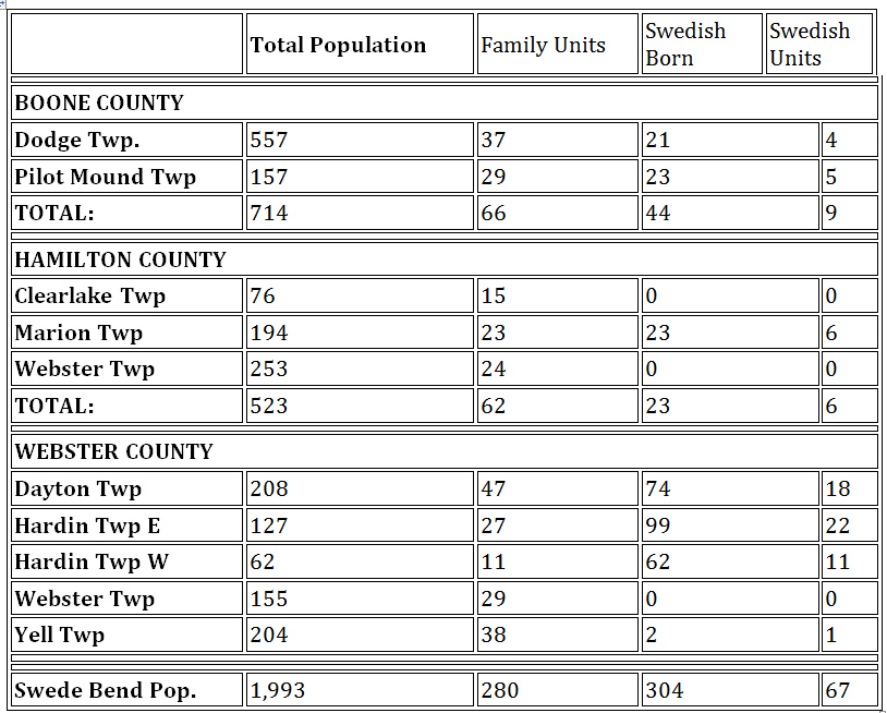
1861-1870 Two events occured in this decade that directly affected Swede Bend: The War Between the States (aka The Civil War or as some called it The War of Northern Aggresion) 1861-1865, curtailed both foreign and domestic movement to the Swede Bend Area. The Swedish crop failures of 1867-1870 hastened emigration by many Swedes during the last years of this period, some came to Swede Bend. In doing the analysis of the 1870 Census several things come to mind. Although the Swede Bend population is increasing, both Swedes and others, some early settlers moved on. A number of Swedes left Swede Bend (most if not all from Hardin Township) for Crawford County. In 1867 a Swedish Settlement was started in the Kiron area. Cheaper (and more) land was available. Some Swede Bend residents sold their holdings and moved on. A list of the people who went to Crawford County can be found on the "Kiron Kountry" website. Google Kiron Kountry then go to the Library Section. A new township, Lost Grove, was established in Webster county immediately west of Dayton Township which was overwhelmingly populated by Swedes. Based on the ages of their children, and their place of birth, it appears most of them arrived in the late sixties. They had a West Dayton post office. The railroads will not arrive in Swede Bend until the early 1880s and there was no new urban development. West Dayton, Homer, Hooks Point Ridgeport, Belleville and Tyson's Mill (Lehigh) were still the closest things to civilization. The Des Moines River will not be bridged in Hardin Township for another two years. Compared to the 1860 census, the 1870 census indicates changes in the makeup of the area are taking place. Professional people (doctors and lawyers) have arrived. Occupations and trades other than farming are beginning to appear (carpenters, blacksmiths, domestic servants, teachers, merchants and clerks, farm laborers, hired hands, draymen, a saloon keeper, and someone who actually listed his occupation as a speculator). Farm laborors and domestic servants are living on the employers premises. More women are being listed as head of household along with their children. Dwellings are now being rented by the occupants. Single settlers are arriving and hiring out their labor. The population increase at first glance indicates people are pouring into the area. Well, yes and no. 47.9% of the total population in Swede Bend are age 15 and younger. The land area is not overpopulated although some of the dwellings may be. The reference to "family units" as used in the 1860 analysis is changed to "dwellings" in the 1870 and subsequent analyses. This change recognizes that all dwellings are now just family units. Analysis Boone County, enumerated August-September 1870 Dodge Twp. The population more than doubled since 1860 from 557 to 1,228 (659 were 15 years of age and younger) living in 226 dwellings. The Swedish population (defined as adults and children born in Sweden, plus children born in the U.S.) grew from 21 individuals to 171 now living in 31 dwellings. Pilot Mound Twp. The population increased even more dramatically from 157 in 1860 to 747 (371 were 15 years of age and younger) living in 148 dwellings. The 21 Swedes in 1860 now number 352 living in 71 dwellings versus the previously 5. Grant Township immediately to the west of Pilot Mound Township has not yet been established. I suspect the people living in this area were enumerated with Pilot Mound Township. When Grant is established and the railroads come to the area, Boxholm will become the trading area. This census lists the Pilot Mound Township postoffice as Perry, Dallas County. Hamilton County, enumerated July-August 1870 Clear Lake Township. The population increased from 76 to 131 people (64 were 15 years of age or younger) living in 24 dwellings. No Swedes were enumerated as living in the township (as yet). Interestingly, of the 55 person increase, 42 were from Norway (including their 21 children 15 years of age or younger plus 4 in one household born in the U.S., living in 6 dwellings, per the census sheets!! The childrens ages indicate that all but one family arrived during the latter part of the decade. The census taker, one F.A. Clark did history no favors. The handwriting leaves much to be desired, with the clearest entry being the census takers name. Stanhope will be the trading center in the future. Marion Township. This township also had a dramatic population increase from 194 to 885 (415 were 15 years of age or younger). Hooks Point, established sometime between 1856 and 1863 (Post Office established in 1863), located north of present day Stratford was one of the few trading centers in the Swede Bend area. There were 169 occupied dwellings in the township, with 404 Swedes occupying 80 of them. The railroad will be laid south of Hooks Point which will then be dismanteled and moved, becoming Stratford. F.A. Clark strikes again. Webster Township, Hamilton County. Population went from 253 in 1860 to 811 (382 children 15 years of age or younger). While there were no Swedes in the township in 1860, there were now 11 living in one dwelling plus a hired hand on a non-Swede farm. The town of Homer in the northwest corner of the township was laid out in 1852 with a post office established in 1854. Homer became an important town in the early days, almost the county seat of Webster County before Hamilton County was formed. Because of its location, Homer was also a trading center for Yell and Webster Townships in Webster County. For the third time, F.A. Clark scribbles his way through this township. Webster County, Enumerated July-August 1870 Dayton Township. At this census, the Swedes and their U.S. born children, became the majority ethnic group in the township. 304 in 1860 now 580 out of a total of 975 people, (including 417 children 15 years of age and younger). West Dayton, the name of the post office, has grown into a town with merchants, a physician, and a smithy. As an aside, a Swede, one Martin Oleson listed as an "agricultural dealer" and a E. Cadwell from Vermont, listed as s "speculator" shared a dwelling. There was no person who was listed as a schoolteacher. The newly established Lost grove township also used West Dayton as their post office and trading center. This sensus taker, W.T. Somers, with very few exceptions, decided to simplify his task by only entering the last name and initials of everybody. His penmanship while better than Mr. Clark would still not stand up to Miss Sarsgard's standards in her 3rd. and 4th. grade Palmer Method penmanship classes at the Stratford grade school. Hardin Township. The cradle of the beginnings of Swedish immigration to this area. Of the 422 people enumerated (including 145 children 15 years of age or younger), 404 were Swedish born including their children born in the U.S. living in 80 dwellings out of the total of 88. In 1860 there were 28 non-Swedes in the population. In 1870 this had shrunk to 18. The population, while growing was proportionally smaller than the other townships. The map shows that about half the township is timber and river. Today some of the timber land has receded due to timber usage but the bottom river land, while excellent for crops was (and still is) iffy due to the frequent spring flooding of the river. I wonder if Mr. Somers was spoken to as this township contains the first names as well as the last. (one of the last townships he enumerated). The Hardin Township Post Office has been changed from Mineral Ridge (Ridgeport), Boone County to Hooks Point, Hamilton County. The township cannot be divided into east and west as Hooks Point is designated as the post office for the entire township. Although the river is not as yet bridged, there was a crossing place up river from where the bridge will be placed known as Peterson's ford (per the Webster County Engineering office). Lost Grove Township . A new township. Lost Grove adjoins Dayton Township immediately to the west. The 1870 census lists the population as 119 individuals. This township is almost pure Swedish. The census lists 119 individuals (52 children 15 years of age or younger. 110 are Swedish born with 17 U.S. born children. There were 21 dwellings of which the Swedes occupied 19. The ages and birthplace of the children indicates that most of these were late comers to the U.S. Their post office is West Dayton. When the railroads arrive Harcourt will be the trading center. Mr. Somers is back to his old habits and all inhabitants are identified only by last name and initials. Webster Township, Webster County. The township population increased from 155 to 520 (including 289 children aged 15 years of age or younger residing in 100 dwellings. As in 1860, no Swedes (as yet) are found in the township. Mr. Somers does provide the first names of the inhabitants. Webster Township is a partial township with, as in Hardin and Yell Townships, the river and timberland traversing the township. Thank you Mr. Somers for including the first names in the census. Yell Township. The population increase was only up from 204 to 349 (including 170 children 15 years of age or younger) in 1870. There is still only one Swedish family which has increased to 4 people plus another Swedish farm hand residing with a non-Swedish family. The name of the post office was listed as Hesperian which was the name of the post office at Burnside. Again, the river and timberland accounting for a large portion of the township. Mr. Somers again provided the first names of the yellites. 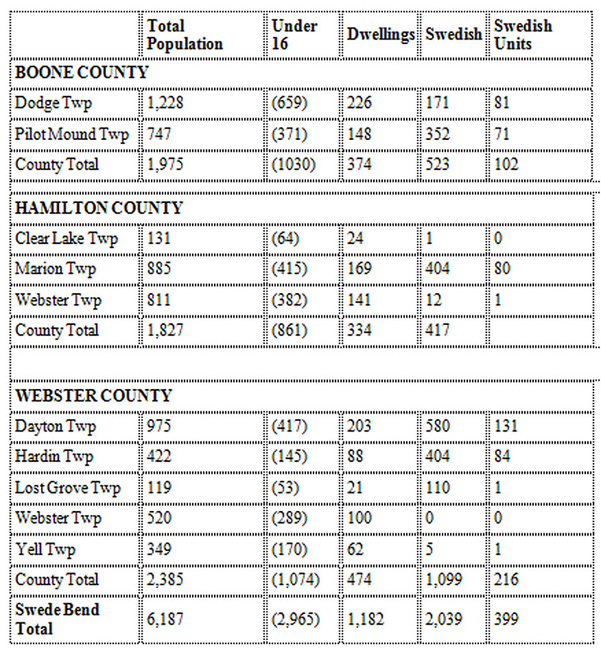
The 1890 census was destroyed by fire. Only fragments exist, none for Iowa. In 1895 Iowa conducted it's own census. This census will be analyzed in the future. During 1881-1890 significant changes took place in Swede Bend. The railroad came through traversing lower Hamilton and Webster Counties. Many towns of Swede Bend were established along this route providing convenient trading centers and shipping points.
|
